


Revolutionized is reader-supported. When you buy through links on our site, we may earn an affiliate commision. Learn more here.
The Amazon Rainforest serves as home to more than 30 percent of the plant and animal species on Earth. It’s a mystery — the massive rainforest holds potential for new medication and foods, yet so much of the forest has experienced damage or devastation. Much of this destruction is due to mining, illegal logging, poaching, slash and burn agriculture, oil prospecting and infrastructure projects.
According to the Amazon Conservation Association (ACA), more than 50 percent of the Amazon Rainforest could perish by the year 2030. Though people think of it as one large rainforest, it’s dozens of different regions and is one of the most biodiverse places on the planet.
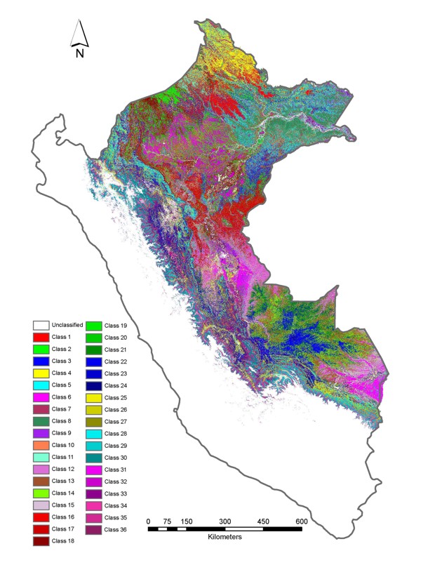
From the air, the Amazon Rainforest appears as one large forest, and it is difficult to map out the different tree species while on the ground. Scientists have found a way to map the region using airborne chemical mapping and analyzing the chemical signatures.
Each tree species carries within it specific chemical traits, like nitrogen and phosphorus. These levels vary between the species. The variation creates a chemical signature seen as a range of colors from a laser-guided imaging spectroscopy with chemical mapping techniques. The colors reveal data. For instance, red indicates strong natural growth chemicals while yellow indicates a lower measurement of these chemicals.
A team of scientists, led by Greg Asner from the Carnegie Institution for Science, studied the Amazon Rainforest from the air using chemical mapping technology. The team mapped the 76-million-hectare forest into 100-kilometer squares and measured the levels of water and other nutrients found in the leaves.
The technology used wavelengths of light reflected from the forest canopy while measuring the defense chemicals commonly found in plants — lignins and polyphenols. The imaging portion of the device created a 3-D image of the rainforest’s structures and natural survival strategies. Asner’s team broke these strategies down into seven traits.
Asner and his team identified 36 types of forest within the Amazon Rainforest and divided these into six general groups. The area’s topography and geography are the basis for these groups. These include: Southern Amazon Lowland Forests, Northern Terra Firme Forests, Floodplain and Swamp Forests, Andean Foothills Forests, Peat Forests and Higher Andean Forests.
The chemical signatures and mapping techniques led the researchers to learn that 27-square-miles of rainforest per year are generally lost due to illegal gold mining and ranching at the base of the Andes. Conservationists can use this information to help protect that particular area.
Conservationists trying to save a particular region of the rainforest may not realize a nearby region holds entirely different species. With the attempt to save one spot, they may lose species across several types of forest without the chemical mapping data. With this new technology, researchers can focus on the most endangered areas first.
The goals of the ACA is to protect the ecosystem, support the communities within the rainforest, protect the natural resources and train the next generation of conservationists. Conservationists can use efficient strategies to meet these goals using the new chemical mapping technology.
Asner’s team is currently working in northern Borneo and Ecuador on similar projects. As it stands, Asner’s plane and sensors are the only ones of their kind, but the researchers believe the technology can work on a global scale.
NASA’s Jet Propulsion Laboratory (JPL) is in talks with Asner about using the chemical mapping techniques from space to monitor the changing biodiversity on Earth by satellite. This satellite would cost $200 million. However, its global mapping would update each month and provide a snapshot of our ever-changing world.
Featured Image by CIFOR and sourced via: Flickr
Revolutionized is reader-supported. When you buy through links on our site, we may earn an affiliate commision. Learn more here.
This site uses Akismet to reduce spam. Learn how your comment data is processed.